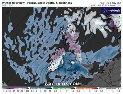
Icy-blue weather maps show swathes of the UK face a brutal 192-hour snow freeze and Arctic temperatures as low as -6C (21.1F). This weekend, the UK is set to enjoy mild November temperatures with the mercury around 15C (59F) in London and bands of rain slowly moving east, followed by brighter skies.
But new WXCharts.com maps for the middle to the end of the month show a dramatic change in the weather as an Arctic freeze takes grip of the UK. Starting on Saturday, November 15, snowfall is set to hit Scotland, the north-west of England and the Midlands - with the temperature in the Scottish Highlands as low as -2C (28.4F).


On Sunday, November 16, fresh snowfall hits Wales and the north-west of England, with deep-purple maps showing the snow from the previous day will have settled across Scotland, with -3C (26.6F) in North-west Scotland and 0C in Wales.
By Monday, November 17, weather charts show the snow settling from Scotland to Cumbria and Snowdonia in Wales, with the mercury at the lowest for the period - an icy -5 and -6C.
On Tuesday, November 18, temperatures in Ireland, mid-Wales, and Scotland are still as low as -5C (23F) with snow still deep in the Highlands - while Wednesday, November 19, will see the mercury still -5C.
Thursday, November 20, is still -3C north of the border while fresh snow scatters across Wales, with snow still blanketing Scotland.
The -3C sub-zero continues into Friday, November 21, with snow still settled in Scotland and by Saturday, November 22 - the eighth day of the Arctic cycle - the mercury drops again to -5C.
The eight days of low temperatures and snow - from November 15 to November 22 inclusive - work out as 192 hours of freezing weather.

Met Office long-range forecasts for Tuesday, November 11 - Thursday, November 20 reveals temperatures are likely to plunge by the end of the month.
It reads: "The start of this period is likely to be largely unsettled and mostly mild, with bands or areas of rain moving across most parts of the UK, although tending to be focused more on western and possibly southern parts.
"Locally strong winds may also accompany the rain at times. Some drier spells are also likely, the best of these probably towards the east and possibly the north.
"Where skies are clear and winds light overnight, frost and fog are likely, the fog slow to clear.
"From around the middle of the month, we may see a transition towards more generally drier weather across the UK, and with this it is likely to turn a little cooler overall, with a greater risk of overnight frost."
You may also like

Uttarakhand CM launches state-level 'Jan Van Mahotsav' in Ramnagar on state formation silver jubilee

Robert Downey Jr. shares rare picture of his wife, and daughter on their birthdays

Jamie Carragher 'blocked from Etihad' by Man City as reason revealed before Liverpool game

Aston Villa vs Maccabi Tel Aviv: Birmingham chaos as fans and Gaza protesters clash

Is Jalen Green playing tonight vs. Los Angeles Clippers? Phoenix Suns star's health status for upcoming game revealed (11-06-2025)


